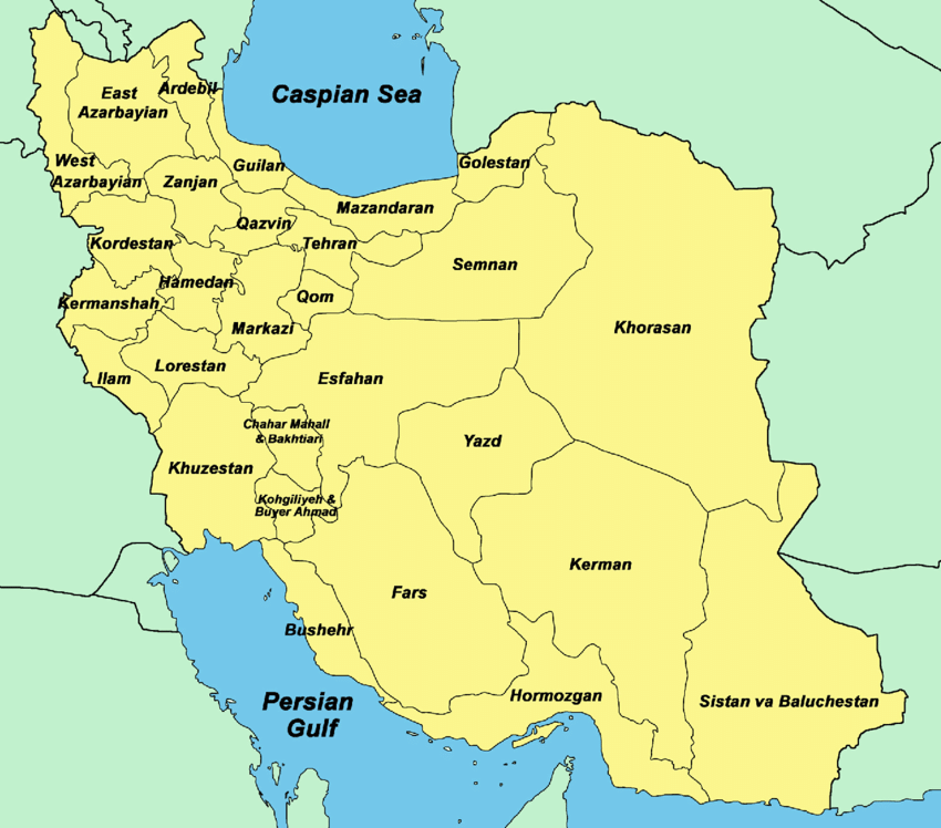
The province of Khuzestan is 63,213 km2 (24,407 sq mi) in the south-west of Iran, bordering Iraq and the Persian Gulf. Ahvaz is the capital of this province and its cities are Abadan, Behbahan, Dezful, Khorramshahr, Bander Imam, Shoush (Susa), Masjed Soleiman, Andimeshk, Mah Shahr, Ramhormoz, Omidiyeh, Shushtar, Izeh, Hoveizeh, Aqa Djari, Shadegan and Soosangerd.
Basically, the province of Khuzestan can be divided into two regions, the plains and mountainous regions. The agricultural lands are fertile and mainly in the west of the province, which are irrigated by the Karun, Karkheh and Jarahi rivers. These three large and permanent rivers flow over the entire territory contributing to the fertility of the land. Karun, Iran’s largest river, 850 kilometers long, flows into the Persian Gulf through this province.
The name Khuzestan, which means “The Land of the Khuzi,” refers to the original inhabitants of this province, the Khuzi people. Khuzestan is situated on the southern part of the Zagros mountain ranges, which covers the north and east of the province. The climate of Khuzestan is generally hot and humid, particularly in the south, while winters are much more pleasant and dry.
The ziggurat of Choqa Zanbil in Khuzestan was a magnificent structure of the Iranian Elamite Empire.
Khuzestan is inhabited by a number of ethnic groups and peoples. Indigenous Persians in major cities, Iranian Arab tribes, the Bakhtiari, Behbahani and Luri of the north, the Qashqai and Afshari tribes, Armenians, the peoples of Dezful, Shushtar and the inhabitants of the coastal regions of the Persian Gulf all make up the population of the province of Khuzestan.
The Persian groups of western Khuzestan all speak distinct dialects unique to their areas. Many Khuzestanis are bilingual, speaking both Persian and Arabic. It is also not uncommon to find people able to speak a variety of indigenous dialects in addition to their own.
Khuzestani folk music is colorful and festive, and each native group has their own rich traditions and legacy in this area.
The people of Khuzestan are predominantly Shi’a, with small Sunni, Jewish and Christian minorities. Khuzestanis are also very well regarded for their hospitality and generosity.
Seafood is the most important part of Khuzestani cuisine, some few to mention are “qaliye-mahi” (fish stew), “qaliye-meygu” (shrimp stew), “ashe-mohshala” (a Khorramshahri breakfast soup) and “soboor” which is prepared with heavy spices, onions and cilantro.
The province of Khuzestan is one of the centers of ancient civilization, based around Susa. French archeologists such as Jaques De Morgan date the civilization here as far back as 8000 BCE when excavating areas such as Tal-e Ali Kosh. The first large scale empire based here was that of the powerful 4th millennium BCE Elamites, a non-Semitic kingdom independent of Mesopotamia. Archeological ruins verify the entire province of Khuzestan to be home to the Elamite civilization.
In previous ages, Iranians referred to Khuzestan as Elam; and historically historians refer to this province as ancient Elam, whose capital was in Susa. Khuzestan is the most ancient Iranian province and is often referred to in Iran as the “birthplace of the nation”, as this is the area where Aryan tribes first settled, assimilating the native Elamite population, and thus laying the foundation for the future Persian Empires of Median, Achaemenid, Parthian and Sassanid.
In 640 BCE, the Elamites were defeated by Ashurbanipal coming under the rule of the Assyrians who wrought destruction upon Susa and Chogha Zanbil. But in 538 BCE Cyrus the Great was able to re-conquer the Elamite lands. The city of Susa was then proclaimed as one of the Achaemenian capitals. Darius the Great then erected a grand palace known as Hadish there in 521 BCE. But this astonishing period of glory and splendor of the Achaemenian dynasty came to an end by the invasion of Alexander of Macedon. And after Alexander, the Seleucid dynasty ruled the area.
As the Seleucid dynasty weakened, Mehrdad I the Parthian (171-137 BCE), gained victory over the region. During the Sassanid dynasty this area thrived tremendously and flourished, and this dynasty was responsible for the many constructions that were erected in Ahvaz, Shushtar and Andimeshk.
The intellectual center or city of Sassanid Empire was Jondishapour (or Gundishapur), founded in 271 CE, by Shapur I, one the most powerful rulers of the Sassanid dynasty, in Khuzestan near Ahvaz and not far from the Karun River. Gundishapur was home to the world’s oldest known teaching hospital, and also comprised a library and a university. According to “The Cambridge History of Iran (vol 4, p396.)”, it was the most important medical center of the ancient world (defined as Europe, the Mediterranean, and the Near East) during the 6th and 7th centuries. Jondishapour medical center was the Mecca of its time, and used to attract the distinguished medical scientists from Greece, Egypt, India, and Rome, shows the importance and prosperity of this region during ancient times.
Jondishapour (or Gundishapur) Academy offered training not only in medicine but also in philosophy, theology and science. The faculties were versed not only in the Zoroastrian and Persian traditions, but in Greek and Indian learning as well
In 639 CE, Arabs Muslims, under the command of Abu Musa Al-Ash’ari from Basra, invaded Khuzestan and drove the Persian Hormozan out of Ahvaz. Susa fell in two days, so Hormozan fled to Shushtar where his forces were besieged by Arab invaders for 18 months. Shushtar finally fell in 642 CE, they, Arab invaders purged the entire Nestorian population of the city along with the Bishop of Hormizd. There after followed the conquests of Jondishapour and of many other districts of Kuzestan. The battle of Nehavand finally secured Khuzestan for the Muslim invaders.